Feeds:
Posts
Comments

Posts Tagged ‘Organizations’

The National Radio Astronomy Observatory is having their first annual Space Race Rumpus.

This unique cycling festival is located at the home of the world’s largest steerable telescope, the Robert C. Byrd Green Bank Telescope, or GBT as we call it around here. The Observatory is located in beautiful Pocahontas County with some of the most scenic roads and trails in the mid-Atlantic. The Space Race Rumpus routes explore both the Observatory’s unique property and the surrounding area.

Over the weekend long event you can participate in guided rides–for both mountain and road enthusiasts–and compete on a cyclocross course right next to eight radio telescopes, including the 485-foot tall GBT. There will be rides and races for all ages and levels, as well as cycling clinics and vendors.
Space Race Rumpus NRAO
Registration
You can register online at BikeReg for single- or multi-day passes. Your registration includes

  •     a t-shirt
  •     cycling clinics by experts
  •     race/ride support
  •     post-race/ride refreshments
  •     kids’ activities/day care
  •     a campsite and bathhouse facilities (with multi-day pass)
  •     live music by The Steel Wheels
  •     movie showings
  •     festive bonfires

All proceeds of the Space Race Rumpus will help the community build a Wellness and Fitness Center in the Green Bank area!

Check back often for updates- or contact us at rumpus-at-nrao.edu or 304-456-2150.

Facebook Page: http://www.facebook.com/SpaceRaceRumpus?sk=wall

Space Race Rumpus

Click for larger image

Read Full Post »

Even the worst rides have great opportunites for taking pics.

For exaple, today’s ride ended up taking me on trails (or lackthereof) that were so rutted out, there were creeks, craters, mud bogs, or rock gardens, luckily, the elevation of an average 8% (felt more like 20% up or down) allowed for some pretty sweet downhills after the steep hike-a-bikes.


I went exploring at our local airport, hearing there was a trail around it…. FAIL. There was nothing but tall grass that went over my handlebars.

After that, I was looking for a way out, and ended up on a deer trail that led me onto a private farm. There were a few cool things to take pics of, but this one was the best op:

Eventually, I made my way onto a familiar road, after having some hereford cows mooing at me for being in their pins (on accident). Decided to take a detour on a gas road I had not been on for a while. This linked up to a VERY STEEP power line trail. Another crappy travel, another great pic:

A view of a good portion of Buckhannon‘s downtown! Look at the powerline angles! 😮

By the time I got home, I was tired, hungry, and cut up like no one’s business. I even managed to find a tick on my arm 😦

After stopping, I could really tell I was bushwacking in deep grasses…. Take a look at my rear hub:

I really wish I would have gone on a road ride with my buddies, but every once in a while, it never hurts to try to break new ground, no?

Read Full Post »

The velomihottie is also a runner, and was outside in the rain at 6am this morning. This kind of dedication to one’s sport is awe inspiring. Don’t get me wrong now, I haven’t picked up running, but I was motivated to go out and ride in today’s heavy downpour. By the time I got home from work, and was kitted up, the roads were already steaming and evaporating the rain off of the hot surfaces. Very eerie!

I’ve been working on a local trail for about two days now, and since it rained today, this was the perfect time to see how well my modifications to the trail have held up. There are about twenty-something coroplast arrows creating a trail path that maximizes the available land, while creating a very efficient and fun topographic course. All I did was cut up some coroplast boxes, make a cardboard stencil, and spraypaint each one with the little arrow design. To create a little less than thirty of them took about half an hour from idea to completion.

mtb trail coroplast signs arrows directions

I’ve been placing them about five feet from the ground, 6-10 feet before a turn on flat sections, and about fifteen feet before a downhill section:

Very easy to see, no?

I’ve dug up some edges around ponds like the one above to allow the water from the rutted out ATV potholes to runoff down the hill, or disperse into wooded/grassy areas. This took a lot of time, but I’ve been wanting to do a lot of this since 2009 or so.

I’m having trouble determining what to do for one section of trail that the ATV’s have decimated with their tires, and there is about a fifty foot section of horizontal ruts full of water. Video below:

Read Full Post »

Well, all in all, the WV Ridge and Valley Excursion was pretty much like any other group ride… but with sag support, and a lot longer distance. There were so many people I knew, that there really was no need to have to learn the riding style of the group because we ride enough together already!

The VH’s father and I had a blast, and took some neat photos and video (More video than photos) along the way. Once I have the videos up, I will post those too!


If you didn’t go this year, be sure to go next year! The Habitat for Humanity group really had a great support team, and accomodated us so well, I wish all of my really long rides were like that! The money goes to a direct, and great cause, which should receive as much attention as possible!

Cowen, WV, Marlinton, Cass, Pocahontas County, Nicholas County, Webster County, Webster Springs, Monongahela National Forrest

Cowen, WV, Marlinton, Cass, Pocahontas County, Nicholas County, Webster County, Webster Springs, Monongahela National Forrest

Almost half way there!


Read Full Post »

Habitat for Humanity is sponsoring the WV RAVE (Ridge and Valley Excursion Bike Tour) on Saturday, June 4, beginning at 8:00 a.m. at Camp Caesar, near Cowen. Habitat for Humanity of Nicholas and Webster Counties will host this bike tour along the scenic Williams River and through the Monongahela National Forest with astounding views and breathtaking climbs! Three routes are offered, so everyone from beginners to avid cyclists will want to participate. This is the third annual edition of the tour, with the previous two being significantly helpful in bringing help to local families.

Ride Date:

June 4, 2011 at 8am.  All cyclists start from Camp Caesar parking lot.

Starting location: Camp Caesar – 4868 Webster Road – Cowen, WV 26206 ( MAP )

Take I-79 to Exit 57 (Summersville, Beckley) and follow Rt. 19 South for 10.5 miles. Turn left onto Rt. 82 at Brich River. At the end of Rt. 82, turn left onto Rt. 20. Camp Caesar is 5 miles on the left. All cyclists begin and end at the camp.

Rides to Choose From:

  • Family Fun Ride (10 miles) This relatively flat route runs part way up Williams River Road and back. Scenic Williams River Valley
  • Endurance Ride (50 miles) A mostly flat route that runs to Tea Creek Campground and back.
  • Ridge Riders (75 miles) Includes a 4 mile climb and 8 mile descent on the Highland Scenic Highway (Rt. 150).
  • Top of the World Century Ride (100 miles) Route includes a 5-mile climb and 5 or 6 other challenging, but shorter, climbs on the Highland Scenic Highway. Will go into Marlinton and return on Williams River Road.

Courses will be well marked for directions and hazards!

Lodging Special at Camp Caesar

$50 – Price includes 2 nights (Fri. and Sat.) lodging at Camp Caesar 4-H Camp, Friday evening meal, and light breakfast Saturday morning in the Camp Cafeteria. For lodging package, call Betsy Morris, Camp Caesar Director at (304) 226-3888 or e-mail campcaesar@frontiernet.net. Bike clubs or groups may choose to rent a cabin for their entire group. Late registrations (after 5/14) will pay $9 for dinner and $7 for breakfast.
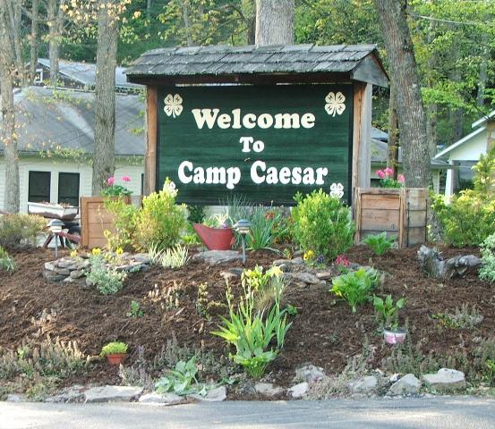
camp caesar 4h camp

Hotels, Motels, Camping

Mineral Springs Motel-Webster Springs (304) 847-5305, plus more motels and hotels are available in Summersville, approximately 45 min. away. For information on campsites available in area and cost per night contact the Forest Service of Richwood (304)653-4825 and Marlinton (304)799-7364.

Registration:

June 3, 2011: 5-7 pm registration and packet pickup at Camp Caesar, Burton Hall.  Cost of ride is $50.  Will take registrations day of ride, but cannot guarantee you will make the starting time.

Packet Pickup:

Packets can be picked up Friday evening from 5-7pm at Burton Hall at Camp Caesar and will include map of chosen course.  Ride packets will not be mailed.

Rave Dinner

Cookout-style dinner upon returning to Camp Caesar after ride.  The cost of the Saturday dinner is included in the $50 registration fee.

More Info:

Contact Sam Barger at 304-619-3552 or email: sambwebcomish@yahoo.com

Contact Audrey Flanagan at 304-742-6276 or email: audreywvmts@yahoo.com

————————————————————————————————–

I’ve been wanting to do this ride for quite a while, but things always tend to pop up in the way of me. Luckily I have been well prepared, and registered way early. We have a gang of people from Buckhannon going, and William Given is meeting up with me for the ride.

Pretty pumped. I haven’t done a 100 mile ride since June of last year, so I’m also a touch bit nervous. I hope to see some of you guys there!

Route Maps:

75 Mile ride: http://ridewithgps.com/routes/397333

100 Mile ride: http://ridewithgps.com/routes/394698

Read Full Post »

Older Posts »